Waterfalls and Lakes
- In Bihar, the drainage pattern is trellis and dendritic due to physical topography of
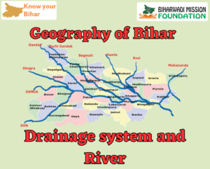
- One of the most striking features of the river system of Bihar is the dominant role of the Ganga. Almost whole of the drainage of Bihar gravitates towards this single waterway.
- It flows for nearly 483 km through the richest tract of the state, swollen with the tribute of innumerable streams that feed its current. The affluent feeding the Ganga arise from two different watersheds – The Himalayas and the Chhota Nagpur plateau.
- The left-bank tributaries, such as the Ghaghra, the Gandak and the Kosi, rise from the Himalayas and are snow-fed perennial streams.
- There are several other streams also, which rise from the foothills of the Himalayas and consequently are not snow-fed.
- Except Son, all the streams that join the Ganga from the south rise from the Chhota Nagpur plateau (now in Jharkhand).
- The plateau is wholly dependent upon the monsoon rain for the supply of water to the rivers that emanate from it. So, they flow full during the rains, swell to flood proportion but shrink in summer to mere trickles, or dry up into drift to sand, broken here and there by stagnant pools.
- Even during the rains, the rivers continue to flow in fairly well-defined valleys and between definite bluffs. Floods take place, when they suddenly burst into level country in West Bengal and to a lesser extent in the South Gangetic Plain of Bihar.
- The rivers that flow down from the plateau to join the Ganga in the north do not have a large catchment area, and they complete their journey too soon.
- Their rush of water may be sudden and violent sometimes, but it is usually of short duration and even in plains the rivers overflow their banks rarely.
- On the other hand, the rivers of north Gangetic plain are well known for floods and their meandering courses. Their catchment area is very large. They are fed by melting glaciers and swelled by heavy monsoon rain.
- They bring down with them an enormous amount of granular particles and sand from the quickly weathering rocks of Himalayan slopes, After entering the plains, they overflow their banks and spread flat and wide
- After entering the plains, they overflow their banks and spread flat and wide over the country-side. Recurrent floods are associated with these shifting channels. The river system of Bihar can be studied under three heads:
- Major Rivers
- The rivers draining into the Ganga from the North.
- The rivers draining into the Ganga from the South.
Major rivers joining the Ganges
|
|
Rivers
|
Confluence point
|
Rivers
|
Confluence point
|
|
Saryu (Ghaghra)
|
Chhapra
|
Gandak
|
Pahleja
|
|
Son
|
Dighwara
|
Karmnasa
|
Chausa
|
|
Falgu
|
Urain (Munger)
|
Kamla
|
Kadhagola
|
|
Kosi
|
Kursela
|
Budhi Gandak
|
Munger
|
|
Mahananda
|
Manihari
|
Bagmati
|
Munger
|
|
Punpun
|
Fatuha (Patna)
|
Kiul
|
Suryagadha
|
Major Rivers
The Ganga
- The origin of Ganga is in the Gangotri glacier in Uttarakhand.
- The Ganga first enters Bihar near its confluence with the Karmanasha in Buxar The three big tributaries- the Ghaghra, the Gandak and the Son join the Ganga are not very far from Patna.
- The Ganga is joined by the Ghaghra, from the north, opposite Sirha, 12 miles north of Arrah by the Son from south, near Bihta; and by Gandak just opposite Patna.
- Moving further east, the Ganga is joined by Punpun from south at Fatuwah in Patna
- The Morhar and the Kiul rivers join it at Surajgarh in Munger, after which it flows northeast to take a sharp bend on reaching high land near Munger town and turns almost due south. It is here that it is joined by the Burhi Gandak from north.
- At Kahalgaon, it mets low range of hills by which it is diverted northward and almost touches the Kosi, which then joins it four miles downstream. Further east, lie the Rajmahal hills which skit its southern bank.
- Ganga almost completely bisects Bihar and flows as an immense stream. Due to this, communication between north and south has always been very difficult. Earlier Boats and steamers were used to ferry for facilitating the movement of goods and people.
- The construction of rail-cum-road bridge at Mokamh, road bridge at Hajipur connecting Patna and road bridge at Bhagalpur connecting Naugachchia have been completed and these bridges have certainly improved the communication between north and south Bihar.
- But there is only one rail-bridge connecting north and south Bihar. So, the railway communication between north and south Bihar is very difficult.
- Two new Mega-bridges (rail-cum-road) are now completed on Ganga. One at Sonpur connecting Digha and other at Munger to Jamalpur.
- Two new bridge on Ganga are under construction. One at Kachi Dargah connecting Bidupur and other at Bakhtiyarpur-Tajpu.
Kamala
- The Kamla originates from Mahabharat range in Nepal near Sindhuliagrarhi It flows into the terai area of Nepal at Chisapani.
- The total length of the Kamala is 328 km out of which 208 km is in Nepal and the remaining 120 km is in India.
- The river drains a total catchment area of 7,232 sq. km out of which 4,488 sq.km lies in Bihar.
- It enters Indian territory in Madhubani district in Bihar, 5 km, upstream of Jainagar (Nepal). A barrage known as Kamala barrage has been constructed by the State Government near Jainagar.
- It joins the river Kareh (Bagmati) at Badlaghat in Khagaria district and the combined stream flows into the Koshi nearby. While one of its branches leads to the Bagmati another leads to the Kosi. In the lower reaches it follows the course of the Balan and is therefore also known as Kamala-Balan.
- The main tributaries of the Kamala river are -Tao, Baijnath Khola Mainawati, Dhauri, Soi, Balan, Trisula, and Chadah.
Major cities of Bihar situated on the banks of Rivers
|
|
|
River
|
Major city
|
|
River
|
Major city
|
|
1.
|
Ganga
|
Patna, Buxar, Bhagalpur, Munger
|
6.
|
Budhi Gandak
|
Samastipur, Khagaria, Muzaffarpur, Bettiah
|
|
2.
|
Saryu
|
Chhapra
|
7.
|
Son
|
Dehri on son
|
|
3.
|
Falgu
|
Gaya
|
8.
|
Kiul
|
Lakhisarai, Kiul
|
|
4.
|
Bagmati
|
Darbhanga
|
9.
|
Gandak
|
Hajipur, Sonpur
|
|
5.
|
Punpun
|
Fatuha
|
10.
|
Dardha
|
Jehanabad
|
-
The Rivers Draining into the Ganga from the North
The principal left bank tributaries of Ganga in Bihar are, from west to east, the Ghaghra, the Gandak, the Burhi Gandak, the Kosi, the Mahananda and their tributaries.
Ghaghra or Saryu
- The river Ghaghra originates from Nampa in nepal and enters Bihar at Gopalganj and joins Ganga at
- The Ghaghra flows for about 96 km along the boundary of the Saran district and Bailia (U.P.). It is liable to inundate the adjoining areas during the rains.
Gandak
- The river Gandak originates at Tibet.
- The Gandak enters Bihar near Triveni and after a course of 321 km through north-west Bihar joins the Ganga at Sonpur and forms a boundary between Uttar Pradesh and Bihar.
- A little to the north-west of its confluence with the Ganga and along its bank is situated in Sonpur, where every year a great bathing festival is held on the occasion of Kartik Purnima, which is also the occasion for the greatest cattle and elephant fair in the world.
- The Gandak is one of the largest tributary of the Ganga and carries an enormous volume of water. It used to cause floods earlier, but now it is protected from its disastrous flood by an embankment.
- The Gandak feeds two important irrigation canals, the Triveni Canal in Champaran and the Saran Canal in Saran.
Burhi Gandak
- The Burhi Gandak originates from Chautarwa Chaur near Bisambharpur in the district of West Champaran in Bihar.
- It is fast flowing river of north Bihar.
- The total length of the river is 320 km. The drainage area of the river is 10,150 sq. km.
- The Burhi Gandak river is a tributary of the Ganges. It is known as Sikrahana in its upper reaches. The Burhi (old) Gandak flows parallel to and east of the Gandak River in an old channel.
- It initially flows through the East Champaran After flowing for a distance of about 56 km. The river takes a southerly turn where two rivers – the Dubhara and the Tiur-join it. Thereafter, the river flows in a south-easterly direction through the Muzaffarpur district.
- The Burhi Gandak runs a zig-zag course through the districts of Samastipur and Begusarai before covering a short distance in Khagaria district, running by the side of the town of Khagaria, and dosen’t flows into the Ganges. It forms the western boundary of the Khagaria town and a protection embankment built along the eastern side of this river, protects Khagaria town from the floods of Burhi Gandak.
- The main tributaries of the Burhi Gandak are Masan, Balor, Pandai, Sikta, Tilawe, Tiur, Dhanauti, Kohra, Anjankote and Danda.
Bagmati
- The Bagmati River runs through the Kathmandu Valley of Nepal and separates Kathmandu from Patan flowing through the Southern Nepal that finally drains into the Indian State of Bihar.
- It is considered holy by both Hindus and A number of Hindu temples are located on its banks.
- The total length of the Bagmati is 597 km out of which 394 km is in Bihar. It enters Bihar in Sitamarhi
- In Bihar, the Bagmati flows across the districts of Darbhanga, Sitamarhi, Sheohar, Muzaffarpur and
- As it flows to Bihar, the river is full with silt load and is notorious for changing its course and braids into many branches one of such branch joins Burhi Gandak river near Begusarai and the combined river drains into Ganga east of Begusarai while the main channel runs east to drain into Koshi at
Kosi
- The Kosi River is 720 km long out of which 260 km area in Bihar and drains an area of about 74,500 km² in Tibet, Nepal and The Kosi River drains the northern slopes of the Himalayas in Tibet and the southern slopes in Nepal.
- From a major confluence of tributaries north of the Chatra Gorge onwards, the Kosi River is also known as Saptakoshi for its seven upper tributaries. It enters Bihar in Supaul
- The Saptakoshi crosses northern Bihar where it branches into distributaries before joining the Ganga near Kursela in Katihar
- Kamala, Bagmati (Kareh) and Burhi Gandak are major tributaries of Kosi River in Bihar, besides minor tributary such as Bhutahi Balan.
- When swollen by heavy rains and melting snow, it inundates large areas, making fresh channels for itself, and ‘turning fertile fields into arid wastes of sand, sweeping away factories, farms, and villages; and changing the whole face of the state from a fruitful landscape into a wilderness of sand and swamp’.
Mahananda
- The Mahananda River is a trans-boundary river that flows through the Indian states of Bihar, West Bengal and Bangladesh,
- The Mahananda originates in the Himalayas Paglajhora falls on Mahaldiram Hill near Chimli, east of Kurseong in Darjeeling district of West Bengal.
- It enters Bangladesh near Tentulia in Panchagarh district, flows for 3 km, after Tentulia and returns to India. After flowing through Uttar Dinajpur district in West Bengal and Kishanganj, Purnea and Katihar districts in Bihar, it enters Malda district in West Bengal.
- The total length of the Mahananda is 360 kilometres (220 mi), out of which 324 km is in Bihar and 36 km is in West Bangal and Bangladesh.
- The main tributaries of the Mahananda are Balason, Mechi, Kankai and River Kalindri.
-
The Rivers Draining into the Ganga from the South
Principal rivers that join Ganga from the south are the Karmanasha, the Son, the Punpun, the Phalgu, the Sakri, and the Kiul. Son is the most important among these rivers.
Son River
- The Son originates from Amarkantak hills in Madhya Pradesh just east of the headwater of the
- It flows north-northwest through Madhya Pradesh before turning sharply eastward, where it encounters the south-west Kaimur Range. It joins the Ganga near Danapur in Patna
- North Koel in Palamu district (Jharkhand) is the only important tributary of the Son. In its lower portion, the bed of the Son is around 3 to 5 km wide, which in the summer season is an enormous stretch of drifting. golden sand with an insignificant silver streak of water.
- It has great agricultural importance. It is the mainstay of very important irrigation works in the state. A big dam (Indrapuri dam) is the starting point of Son canal from Dehri-on-Son.
Funpun
- Itonginates from the Chomanagpur hills of Palama district of Jharkhand.
- The river mostly flows in a northeast direction and finally join the Ganga river at fatuha, about 25 km downstream of Patna.
- The river as 200 km long and is mostly rainfed and carries little discharge during non-monsoon period.
- In the state, it enters in Aurangabad
- The river, while flowing through the Chutangaur plateau, meets a number of tributaries. The tributaries are-Butane, Mador and storhar.
- The Purun river is an important river bank tributary of the Ganga river in lower reaches.
Karmanasha River
- The Karmanasha river originates from Rohtas plateau and joins Ganga near Chausa forming Uttar Pradesh-Bihar border.
- The principal tributaries of Karmanasha are Chandraprabh Durgavati Kanunuti, Nadi and
Phalgu River
- The Phalgu river is formed by the confluence of Lilajan and Mohana, two large hill streams. Phalgu is also known as
- The Phalgu like its confluence streams Lujan and Mohana, is subject to high flood during monsoon. It flows past Gaya and is a sacred river for the Hindus and Buddhist Lord Vishnu’s Temple, Vicheuped Mandir is situated on the bank of liver
Kul River
- The Klul originates from the Tisri hill range in kharagdiha police station area of Giridih district of Jharkhand. After forming the boundary of the district for a short distance, it enters Jamui district in Bihar, through a narrow gorge near the satpahari hill.
- In Bihar, the Kiul river flows through Jamul, Sheikhpur and Lakhisarai districts and joins Harohar/Halahar/Harobar river in the Diara region.
Ajay River
The Ajay river originates from Batpar, Chaka block of jamui district in Bihar. It flows through Jharkhand and enters West Bengal at Simjuri, near Chittaranjan.
Important Rivers of Bihar
|
|
River
|
Originated from
|
Sangam
|
Length in Bihar (in km)
|
Catchment Area in Bihar (sq. km)
|
Enter in Bihar at
|
|
Ganga
|
Gangotri Glacier
|
Bay of Bengal
|
445
|
15,165
|
Buxar
|
|
Ghaghara
|
Nampada (Nepal)
|
Ganga (Chhapra)
|
83
|
2295
|
Saran
|
|
Gandak
|
Mangamat and Kutang (Nepal and Tibet)
|
Ganga (Hajipur)
|
260
|
4188
|
Triveni
|
|
Burhi Gandak
|
Someshwar Hill
|
Ganga (Munger)
|
320
|
9601
|
Champaran
|
|
Baghmati
|
Mahabharata range (Nepal)
|
Kosi
|
394
|
6500
|
Sitamarhi
|
|
Kamala
|
Mahabharata range
|
Bagamati
|
120
|
4488
|
–
|
|
Kosi
|
Saptkosi (Nepal)
|
Ganga (Kursela)
|
260
|
11,410
|
–
|
|
Mahanada
|
Mahabharata range (Nepal)
|
Ganga (Katihar)
|
376
|
6150
|
Purnea
|
|
Darmanasha
|
Vindhyachal range
|
Ganga (Chawa)
|
–
|
–
|
–
|
|
Son
|
Amarkantak (M.P.)
|
Ganga (Patna)
|
202
|
15,820
|
–
|
|
Punpun
|
Chauraha hill Palamu (Jharkhand)
|
Ganga (Fatuha)
|
235
|
7747
|
–
|
|
Falgu
|
North Chhota Nagpur Plateau (Jharkhand)
|
Ganga
|
–
|
–
|
–
|
|